Pacific Cyclones Tracker: Two Hurricanes and Typhoons
The Pacific Ocean is currently experiencing a surge in storm activity, with multiple Pacific Cyclones threatening various regions. This heightened activity underscores the importance of staying informed and prepared for rapidly changing weather conditions.
Hurricane Gilma Intensifies to Category 4

Hurricane Gilma has rapidly intensified, now reaching the formidable status of a Category 4 storm. The storm’s strength is causing significant disruption in the Pacific Ocean, with turbulent sea conditions that are proving hazardous to maritime activities. Swells reaching up to 3.5 meters are being reported, making it extremely dangerous for ships and coastal regions alike.
Impact on Sea Conditions
The powerful winds generated by Hurricane Gilma are whipping up the ocean into a frenzy. Maritime experts are advising all vessels in the vicinity to either seek shelter or alter their courses to avoid the storm’s path. The swells and turbulent conditions are expected to persist as long as Gilma remains strong.
Potential Coastal Threats
Although Gilma is currently far from land, the storm’s size and intensity mean that coastal areas may still experience its effects. High surf advisories and potential coastal flooding are concerns for areas that could be brushed by the outer bands of the hurricane.
Hone Brushes Past Hawaii

Hurricane Hone, though not as intense as Gilma, has caused significant concern as it passed close to Hawaii. The proximity of the storm brought with it strong breaking waves and high winds that have left their mark on the islands.
Wind and Wave Impact
As Hone neared the islands, residents and visitors were warned to stay away from beaches and exposed areas. The strong winds and waves posed a risk of injury and damage to coastal infrastructure. Although the worst of the storm has passed, cleanup efforts are underway to address the aftermath.
Heavy Rainfall on Big Island
The eastern side of the Big Island of Hawaii bore the brunt of Hone’s rainfall, with reports of up to 110mm of rain in a short period. This downpour led to localized flooding and has raised concerns about potential landslides in vulnerable areas. Emergency services are on high alert to respond to any incidents arising from the saturated ground.
Typhoon Shanshan Approaches Japan

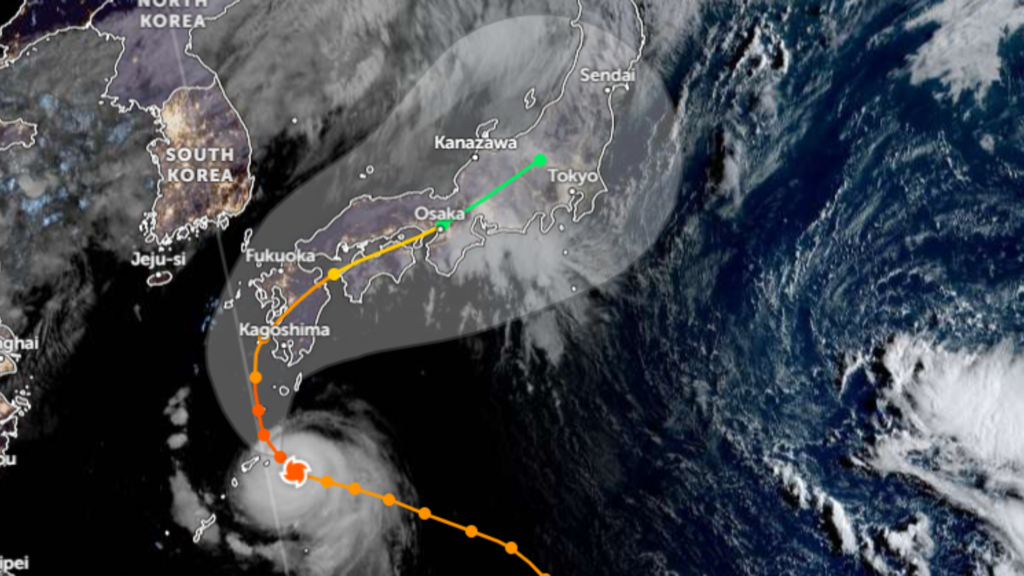
Meanwhile, on the other side of the Pacific, Typhoon Shanshan is making its approach towards Japan. This storm is currently packing sustained wind speeds of 75mph, with gusts reaching up to 110mph, and it shows no signs of weakening.
Forecast for Intensification
Weather models predict that Shanshan will reach very strong typhoon status by Tuesday. The storm’s sustained winds are expected to exceed 97mph, bringing with it the potential for widespread destruction. Japan’s Meteorological Agency has issued warnings, urging residents to prepare for the worst.
Threat to Infrastructure
The destructive potential of Typhoon Shanshan cannot be underestimated. The storm’s winds are capable of causing severe damage to buildings, power lines, and transportation networks. Authorities are taking proactive measures, including the suspension of public transportation and the reinforcement of structures in vulnerable areas.
Rainfall and Flooding Concerns
Along with the wind, Shanshan is expected to bring torrential rains, with some models predicting over 300mm of rain within 24 hours. This amount of rainfall raises the risk of flash flooding and landslides, particularly in mountainous regions. Evacuation plans are being considered for areas most at risk.
The Pacific Ocean’s current storm activity is a stark reminder of the power of nature. With Hurricane Gilma’s intense winds, Hone’s heavy rainfall in Hawaii, and the looming threat of Typhoon Shanshan in Japan, it’s clear that preparedness is key. Residents in affected areas should stay informed, follow the advice of local authorities, and have a plan in place to respond to these dangerous weather events.
